Geierköpfe - a magnificent crossing in the Reutte Nature Park region
2,521 views

About :
If you liked it, please give it a thumbs up ???? and I would be very happy if you subscribe to my channel. ???? The challenging crossing of the Geierköpfe mountain range in the Ammergau Alps is a technically demanding and scenically impressive mountain tour and is a popular pleasure tour for experienced mountaineers. With a bit of luck, you'll have most of the tour to yourself, as the main summit, 2,161m, and the east summit, 2,060m, are rarely climbed. Only the west summit, 2,143m, is a popular destination for hikers, as it can be reached on various hiking trails without major technical difficulties. The tour leads through steep grass and scree terrain, slopes covered with mountain pines. At the top of the mountain, the path should not be underestimated due to the gravel. On the airy ridge, the path is often exposed and several climbing sections up to a maximum difficulty level of II must be overcome in the brittle rock. The view from the ridge is worth all the effort. To the north, the rock faces drop steeply. The varied ridge hike offers a clear view of Hochplatte, Säuling, Thaneller, the Lechtal, Ammergau and Werdenfelser Alps. To the southeast, the broad ridge of the Zugspitze dominates the horizon and from the western summit you can see the elongated Plansee, surrounded by the many peaks in the area. The starting point for this tour is the car park halfway between Ammerwald and Plansee through the Teufelstal via the Zwerchenberg hunting lodge and the Kreuzjöchl, 1,900 m, to the Geierkopf western summit. Ascent time approx. 3.5 hours. Continue to the main summit approx. 1 hour and to the eastern summit approx. 1 hour. For the entire crossing, approx. 1,650 m of ascent and descent must be overcome. The descent from the eastern summit is pathless over the eastern ridge to the southern slope trail - Neualpe, Pt. 1666. This high-altitude trail takes you back to the Kreuzjöchl. In addition to a head for heights, surefootedness and a sense of direction, you also need to have very good stamina and fitness. Alternatives to the ascent: 1. Car park at the Musteralm on the northeast shore of Lake Plansee, Opelhaus, the Zwerchenbergweg to the Zwerchenberg hunting lodge and further to the Kreuzjöchl, 1,900m 2. Car park on the northeast shore of Lake Plansee (near Seewinkl), to path 243 to the Schönjöchl 1,661m, and via the Zwerchenberg hunting lodge further to the Kreuzjöchl, 1,900m 3. Car park "Bei den Sieben Quellen" in the direction of Neualpe - Neualpgries, Pt. 1666, from here continue on the south slope trail to the Kreuzjöchl and to the Geierkopf west summit or in the reverse order, first the east, then the main and then the west summit. Then descend via Kreuzjöchl, south slope and back again. Note: Mountain climbing is dangerous. A mountain tour is always weather dependent. So always find out about the weather and conditions beforehand. Sure-footedness on steep, grassy, rocky, scree, snow and ice terrain, a sense of direction, a head for heights and good physical condition are basic requirements and urgently required for a climb. Music from Youtube: / @sigisbergtouren Music from Frametraxx: https://www.frametraxx.de/info/kosten... Music from musicfox.com: https://www.musicfox.com/info/kostenl...

214,066 views 2 days ago


481,294 views 5 days ago

1,464,083 views 3 days ago


285,920 views 5 days ago


213,443 views 5 days ago
285,920 views 5 days ago


319,164 views 1 day ago


481,294 views 5 days ago

545,228 views 4 days ago


557,648 views 2 days ago


406,531 views 6 days ago


1,520,933 views 3 days ago


406,531 views 6 days ago
Google AdSense
336 x 280
336 x 280
Up Next

Bosco di Ogigia
11,290 views
Streamed 2 years ago
Streamed 2 years ago

Bosco di Ogigia
1,362 views
3 hours ago
3 hours ago


terranuovaedizioni
6,954 views
Streamed 2 years ago
Streamed 2 years ago


Bosco di Ogigia
25,689 views
Streamed 2 years ago
Streamed 2 years ago

Bosco di Ogigia
31,017 views
Streamed 1 year ago
Streamed 1 year ago
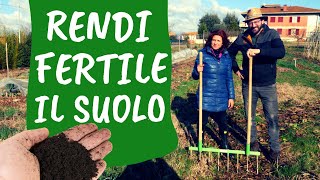
Orto Da Coltivare
86,122 views
8 months ago
8 months ago

Contea Mezzaluna-sito in Permacultura
15,361 views
3 months ago
3 months ago

Bosco di Ogigia
68,558 views
Streamed 3 years ago
Streamed 3 years ago

Adelaide Valentini
9,000 views
3 years ago
3 years ago

Bosco di Ogigia
14,865 views
Streamed 2 years ago
Streamed 2 years ago


Giardinaggio con Charles Dowdling
16,296 views
1 month ago
1 month ago


Rendita Agricola
123,498 views
1 year ago
1 year ago

Eisenbahn in Ö, D, CH
25,642 views
1 day ago
1 day ago

Eisenbahn in Ö, D, CH
84,762 views
1 year ago
1 year ago

Christian der Auswanderluchs
3,593 views
5 hours ago
5 hours ago


aufschiene
44,530 views
3 months ago
3 months ago

NZZ Format
48,583 views
5 years ago
5 years ago

Bahnprojekt Stuttgart–Ulm
140,355 views
1 month ago
1 month ago

Bahnwelten
93,254 views
1 month ago
1 month ago
Fanshop Schweiz
16,457 views
1 year ago
1 year ago

NDR Doku
553,354 views
11 days ago
11 days ago
Fanshop Schweiz
28,523 views
1 year ago
1 year ago

Grimm-Weinheim MHI Modellbahnfachgeschäft
153,597 views
1 year ago
1 year ago


Eisenbahn in Ö, D, CH
243,686 views
2 years ago
2 years ago
Google AdSense
336 x 280
336 x 280